
Ceglak Rally 2024 – searching for a student
WRSS WILiGZ is back! And with them the next edition of the Ceglak Rally 2024!


According to this title, in October you can find it in the Faculty Library our next news, let’s call them HOT ROLLS as usual. This month we bet on a two fields of science that fit tightly together, that are geodesy and cartography. Surveyor surveying can be done for many different ways and has applications. Obviously, the most salient effects of these measurements will be included in the map. They may refer, among others, to extensive areas t(country, continent). But they can only refer to very small areas like (plot). The results of the work have a scientific function, but may also have a economic function. Security in a broad sense depends on the acquired and processed information that is created while creating new buildings.
Detailed information about our news can be found below this post.
We will endeavor to provide you with information about our next news on a regular basis. We are also waiting for suggestions of new book and magazine titles. Look for information about our “hot rolls” always here. In addition, pay attention to the boards of the A1 and A4 items on display – there will also be an information about new books!
| Author, title, year of the publication | A short description of topic | Book cover |
| Prószyński W., Kwaśniak M.: Podstawy geodezyjnego wyznaczania przemieszczeń, wyd. 2006 | The book is devoted to the conceptual and terminological layer of determining the displacements of engineering structures and their surroundings on the basis of geodetic measurements. The concepts relating to the basic methods of processing the results of this type of measurements are discussed. Only at the definition level, specialized processing of the measurement results was indicated. The theoretical background is illustrated with numerical examples, provided with detailed explanations. |  |
| Barlik M., Pachuta A.: Geodezja fizyczna i grawimetria geodezyjna, wyd. 2007 | The book is a textbook on that part of the field of higher geodesy which deals with the influence of the gravity field generated by the Earth on the elaboration of the results of geodetic, astronomical and satellite observations. |  |
| Rogowski J., Kłęk M.: Geodezja satelitarna, wyd. 2009 | The book on the basics of satellite geodesy discusses the use of global navigation systems GNNS. |  |
| Łyszkowicz A.: Geodezja fizyczna, wyd. 2012 | The textbook is intended not only for students, but also for those who feel the need to understand the Earth’s gravity field and methods of studying the geoid course, its importance in defining the altitude system, and satellite methods of determining altitude relative to mean sea level. |  |
| Dąbrowski J.: Zagadnienia geodezji inżynieryjnej dotyczące inwestycji drogowych, wyd. 2014 | The item describes the issue of geodetic investment management. The author focuses on the legal basis of road surveying. |  |
| Gruszczyński S.: Analiza danych kartograficzno-glebowych w procedurach ocen oddziaływania na środowisko, wyd. 2008 | The environmental impact assessment is one of the most important elements of the environmental policy. The paper presents methods of IT support for soil condition assessment. |  |
| Gajderowicz I.: Kartografia matematyczna dla geodetów, wyd. 1999 | The manual was adapted to the needs of surveyors and cartographers. Describes the problems of cartographic mapping and the distortions that occur. It can also be used by geographers who present the studied natural and socio-economic phenomena on maps. |  |
| Gajederowicz I.: Odwzorowania kartograficzne, wyd. 2009 | The manual was adapted to the needs of surveyors and cartographers. Describes the problems of cartographic mapping and the distortions that occur. It can also be used by geographers who present the studied natural and socio-economic phenomena on maps. |  |
| Żyszkowska W. , Spallek W., Borowicz D.: Kartografia tematyczna, wyd. 2012 | The manual covers thematic maps that present objects, phenomena, as well as physical and abstract processes related to selected elements of the geographical environment, occurring on, under and above the Earth’s surface. They visualize not only the location of individual objects or phenomena appearing in space, but also their qualitative or quantitative features, structure and relationships with which they are related to other phenomena or features. Thematic maps fulfill many functions in science. The publication will be especially useful for students of cartographic specialization, geodesy and cartography, as well as geography and related fields of study. | 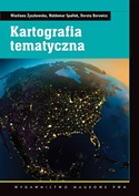 |
| Medyńska Gulij B.: Kartografia i geowizualizacja, wyd. 2012 | A textbook on contemporary cartography in its most important areas, with an emphasis on new technologies. It is intended for students and specialists in fields related to geographic space. Academics who use maps and other forms of geovisualisation in their research work will obtain specific information about the availability of contemporary data sources. | |
WRSS WILiGZ is back! And with them the next edition of the Ceglak Rally 2024!

We invite everyone to participate in the oLEANpiada which oLEANpiada will be held on April 22, 2024 at the AGH University of Science and Technology in Krakow.